Measure Area From Any Photo or Image
Calibrate the image with one known distance, draw a polygon or circle, and get the area instantly — in metric or imperial units. Works on floor plans, drone shots, maps, and technical drawings.
How Area Measurement Works
Img Meter turns any image into a measuring surface using a two-step process.
Calibrate the image
Mark two points on the image and tell the app the real-world distance between them — for example, “these two marks are 2 meters apart.” The app calculates a pixel-to-unit scale from this reference.
Draw the shape
Use the Polygon tool to outline any region, or the Circle tool (two clicks define the diameter). The app instantly calculates the area in your chosen unit system.
Area is derived from pixel geometry scaled by the calibration ratio. For polygons, area comes from the outline you draw; for circles, from the diameter you set.
When It's Accurate — and When It Isn't
When it's accurate
- The subject is flat — a floor plan, a field viewed from above, a wall, a tabletop.
- The camera was roughly perpendicular to the surface, with no strong tilt.
- The calibration reference is on the same plane as what you're measuring.
- The calibration distance is as long as possible relative to the image — a short reference amplifies rounding error.
When accuracy drops
- Perspective or camera tilt — distorts farther regions and skews areas near the edges of the frame.
- Curved surfaces — a barrel, a hill, or a rounded wall cannot be measured accurately from a flat projection.
- Short calibration reference — small drawing errors translate into large real-world errors.
- Calibration on a different plane — measuring a wall while calibrating against a floor introduces a systematic scale error.
- Lens distortion — fisheye or wide-angle lenses bow straight lines; the app has no lens-correction step.
Supported units
Measure and convert across every unit img-meter supports, grouped by system and subsystem.
Area
Metric
| Symbol | Name |
|---|---|
| mm² | square millimetre |
| cm² | square centimetre |
| m² | square metre |
| km² | square kilometre |
| ha | hectare |
Imperial
| Symbol | Name |
|---|---|
| in² | square inch |
| ft² | square foot |
| yd² | square yard |
| mi² | square mile |
| ac | acre |
Astronomical
| Symbol | Name |
|---|---|
| AU² | square astronomical unit |
| ly² | square light-year |
| pc² | square parsec |
Practical Use Cases
Anywhere you have a photo and a known distance, you can measure area.
Architecture & Construction
Estimate floor area from a plan photo or overhead drone shot. Measure wall sections for tiling, painting, or cladding quotes.
Agriculture & Land
Estimate crop patch or field area from a satellite or drone image. Measure irrigation zones and plot subdivisions.
Interior Design
Calculate carpet or flooring area from a room plan. Measure countertop or backsplash areas from a photo.
Engineering & Manufacturing
Measure cross-section areas on technical drawings or part photos. Estimate surface areas of flat components.
Real Estate
Quick area checks on floor plan images before a formal survey. Verify room dimensions from listing photos (flat ceilings and floors only).
Education & Research
Measure geographic features on maps — lakes, clearings, building footprints. Planimetry on scanned field sketches or diagrams.
Frequently Asked Questions
? What units can I measure area in?
Any unit you calibrate with. Set the reference distance in meters and you get square meters; set it in feet and you get square feet. The app supports metric and imperial unit systems.
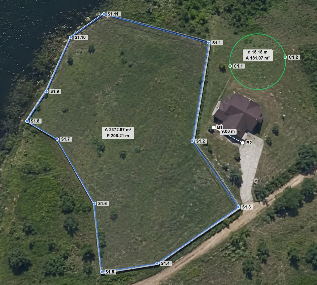
? Can I measure area on a drone or satellite image?
Yes — these are some of the best images to use, because the camera is roughly perpendicular to the ground. Just calibrate against a known distance in the image (a road width, a building edge, or a placed marker) and draw your shape.
? How accurate is the measurement?
Accuracy depends mostly on the image. If the subject is flat, the camera was perpendicular, and the calibration reference is long and on the same plane, results are typically within a few percent. Tilt, lens distortion, and curved surfaces all reduce accuracy.
? Can I measure irregular shapes?
Yes. The Polygon tool lets you outline any region with as many points as you need. For circular regions, the Circle tool takes two clicks to define the diameter.
? Is my image uploaded to a server?
No. All processing happens in your browser — your images never leave your device.
Measure your first area in under a minute
Open the app, drop in your image, calibrate once, and start drawing. No sign-up required.